
TABLE OF CONTENTS
📝1. Short Notes for Revision
Introduction to India
- Ancient Civilization: India is one of the world’s oldest civilizations, with significant socio-economic progress in agriculture, industry, technology, and economy over the last five decades.
- Contributions to World History: India has influenced global history through ideas like Upanishads, Ramayana, Panchtantra stories, Indian numerals, and decimal system; also exchanged spices, muslin, and absorbed Greek sculpture and West Asian architecture.
Location
- Geographical Extent: Lies entirely in Northern Hemisphere; mainland between latitudes 8°4’N (southernmost) and 37°6’N (northernmost); longitudes 68°7’E (westernmost) and 97°25’E (easternmost).
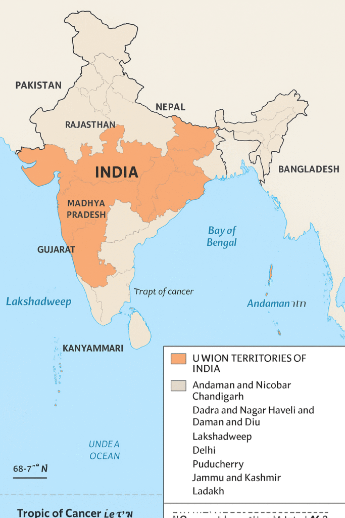
- Tropic of Cancer: At 23°30’N, divides India into two nearly equal parts; passes through Rajasthan, Gujarat, Madhya Pradesh, Chhattisgarh, Jharkhand, West Bengal, Tripura, Mizoram.
- Island Groups:
- Lakshadweep: In Arabian Sea (southwest of mainland).
- Andaman and Nicobar: In Bay of Bengal (southeast of mainland).
- Key Fact: Southernmost point Indira Point submerged in 2004 Tsunami.
Size
- Land Area: 3.28 million sq km (2.4% of world’s geographical area); seventh largest country globally.
- Land Boundary: 15,200 km.
- Coastline: 7,516.6 km (including islands).
- Comparison: North-south extent ~3,214 km; east-west ~2,933 km; latitudinal/longitudinal extent both ~30°, but east-west appears smaller due to convergence of meridians.
- Standard Meridian: 82°30’E (passes through Mirzapur, UP); time lag of ~2 hours from Gujarat to Arunachal Pradesh; influences day-night duration (minimal at Kanyakumari, more at Kashmir).
India and the World
- Strategic Location: Central between East and West Asia; southward extension of Asia; Deccan Peninsula protrudes into Indian Ocean, aiding trade with West Asia, Africa, Europe (west coast) and Southeast/East Asia (east coast).
- Trans-Indian Ocean Routes: Connect Europe and East Asia; longest coastline on Indian Ocean; named after India.
- Suez Canal Impact: Opened in 1869, reduced distance from Europe by 7,000 km.
- Historical Contacts: Land routes (passes in north) older than sea routes; facilitated exchange of ideas/commodities.
India’s Neighbours
- States and UTs: 28 States and 8 Union Territories (as per text; note: current may vary slightly).
- Land Boundaries: Shares with Pakistan, Afghanistan (NW); China (Tibet), Nepal, Bhutan (N); Myanmar, Bangladesh (E).
- Sea Neighbours: Sri Lanka (separated by Palk Strait and Gulf of Mannar); Maldives (south of Lakshadweep).
- Pre-1947 Structure: Provinces (British-ruled) and Princely States (local rulers under British suzerainty).
- Indian Subcontinent: Includes India, Pakistan, Bangladesh, Nepal, Bhutan, Sri Lanka, Maldives.
- Key Resource: School Bhuvan Portal (NRSC/ISRO) for map-based learning on natural resources and sustainable development.
🎯2. Multiple Choice Questions (MCQs)
- India is one of the ancient civilizations in the world and has achieved progress in which fields? (a) Agriculture, industry, technology (b) Sports, arts, literature (c) Mining, fishing, tourism (d) Banking, insurance, trade
- The mainland of India extends between which latitudes? (a) 8°4’N and 37°6’N (b) 68°7’E and 97°25’E (c) 23°30’N and 82°30’E (d) 0° and 90°N
- Which line divides India into almost two equal parts? (a) Equator (b) Tropic of Cancer (23°30’N) (c) Standard Meridian (d) Tropic of Capricorn
- The Andaman and Nicobar Islands lie in which sea? (a) Arabian Sea (b) Bay of Bengal (c) Indian Ocean (d) Pacific Ocean
- What is the total area of India? (a) 3.28 million sq km (b) 15,200 sq km (c) 7,516.6 sq km (d) 2.4 million sq km
- India ranks as the _____ largest country in the world. (a) Fifth (b) Seventh (c) Third (d) Tenth
- The total length of India’s land boundary is: (a) 3.28 million km (b) 7,516.6 km (c) 15,200 km (d) 30° km
- Which mountains bound India in the northwest, north, and northeast? (a) Aravalli (b) Young fold mountains (Himalayas) (c) Western Ghats (d) Eastern Ghats
- The east-west extent of India appears smaller than north-south due to: (a) Latitudinal convergence (b) Longitudinal convergence of meridians (c) Island groups (d) Coastal length
- The Standard Meridian of India is: (a) 68°7’E (b) 82°30’E (c) 97°25’E (d) 23°30’N
- Time lag between Gujarat and Arunachal Pradesh is: (a) One hour (b) Two hours (c) Three hours (d) Four hours
- India’s central location is between: (a) North and South America (b) East and West Asia (c) Europe and Africa (d) Australia and Antarctica
- The Deccan Peninsula helps India connect with: (a) Only Europe (b) West Asia, Africa, Europe, and Southeast Asia (c) Only East Asia (d) North America
- The Suez Canal reduced India’s distance from Europe by: (a) 3,000 km (b) 7,000 km (c) 15,200 km (d) 30° km
- Which ancient ideas spread via land routes? (a) Upanishads, Ramayana, Panchtantra (b) Greek sculpture only (c) Modern technology (d) Spices and muslin
- India has how many states and Union Territories? (a) 28 states, 8 UTs (b) 29 states, 7 UTs (c) 27 states, 9 UTs (d) 30 states, 6 UTs
- Which country does India share land boundary with in the northwest? (a) China (b) Pakistan and Afghanistan (c) Myanmar (d) Sri Lanka
- Sri Lanka is separated from India by: (a) Bay of Bengal (b) Palk Strait and Gulf of Mannar (c) Arabian Sea (d) Maldives
- Before 1947, India had: (a) Only provinces (b) Provinces and Princely States (c) Only Princely States (d) Union Territories
- The southernmost point of India is: (a) Kanyakumari (b) Indira Point (c) Lakshadweep (d) Andaman
Correct Answers:
- (a) 2. (a) 3. (b) 4. (b) 5. (a) 6. (b) 7. (c) 8. (b) 9. (b) 10. (b) 11. (b) 12. (b) 13. (b) 14. (b) 15. (a) 16. (a) 17. (b) 18. (b) 19. (b) 20. (b)
💬3. Very Short Answer Type Questions (VSAQs)
- What is the latitudinal extent of India’s mainland? Answer: 8°4’N to 37°6’N.
- Name the southernmost point of India. Answer: Indira Point.
- What is the area of India in square km? Answer: 3.28 million sq km.
- Which meridian is the Standard Meridian of India? Answer: 82°30’E.
- Name the island group in the Arabian Sea. Answer: Lakshadweep.
- What is the total coastline length of India including islands? Answer: 7,516.6 km.
- How many countries are larger than India in area? Answer: Six (Russia, Canada, USA, China, Brazil, Australia).
- Name the two seas divided by the Indian mainland. Answer: Arabian Sea (west) and Bay of Bengal (east).
- What is the time lag between Gujarat and Arunachal Pradesh? Answer: Two hours.
- When was the Suez Canal opened? Answer: 1869.
- Name India’s southern sea neighbours. Answer: Sri Lanka and Maldives.
- How many states does India have? Answer: 28.
- What separates Sri Lanka from India? Answer: Palk Strait and Gulf of Mannar.
✍️4. Short Answer Type Questions (SAQs)
- Why is the east-west extent of India smaller than the north-south extent despite similar degrees?
- Answer: The latitudinal and longitudinal extents are both about 30°, but meridians converge towards the poles, making the east-west distance shorter (2,933 km) compared to north-south (3,214 km).
- Explain the significance of the Standard Meridian of India.
- Answer: The 82°30’E meridian passes through Mirzapur, UP, and is used as the standard time for the whole country to avoid confusion from the two-hour time lag between eastern and western extremities.
- How does India’s location influence the duration of day and night?
- Answer: The latitudinal extent from 8°4’N to 37°6’N causes variation; near the equator (e.g., Kanyakumari), day and night are almost equal, but further north (e.g., Kashmir), days are longer in summer and shorter in winter due to the Earth’s tilt.
- Describe India’s strategic position in the Indian Ocean.
- Answer: India’s Deccan Peninsula protrudes into the Indian Ocean, providing the longest coastline and connecting trade routes to Europe, Africa, West Asia (west coast), and Southeast/East Asia (east coast), making it a key maritime hub.
- What role did land routes play in India’s historical contacts?
- Answer: Northern mountain passes allowed ancient travelers to exchange ideas like Upanishads and Ramayana, and commodities like spices; this predated sea routes and spread Indian culture globally.
- List India’s land neighbours and their directions.
- Answer: Northwest: Pakistan, Afghanistan; North: China (Tibet), Nepal, Bhutan; East: Myanmar, Bangladesh.
- Why is India called a southward extension of the Asian continent?
- Answer: It forms a peninsula extending south into the Indian Ocean, bounded by young fold mountains in the north, separating it from the rest of Asia while linking it strategically.
📖5. Long Answer Type Questions (LAQs)
- Discuss the size and location of India and its implications for time and climate.
- Answer: India covers 3.28 million sq km, 2.4% of world’s area, with a land boundary of 15,200 km and coastline of 7,516.6 km. Located in the Northern Hemisphere (8°4’N to 37°6’N, 68°7’E to 97°25’E), the Tropic of Cancer divides it equally. The 30° extent causes a two-hour time lag, resolved by the 82°30’E Standard Meridian. Latitudinal spread affects climate: tropical south has uniform days/nights, while northern temperate zones have seasonal variations, influencing agriculture and lifestyle.
- Explain India’s relations with the world through historical trade routes and its current strategic importance.
- Answer: Ancient land routes via northern passes spread Indian ideas (Upanishads, numerals) and goods (spices, muslin) to the world, while absorbing Greek and West Asian influences. Sea routes were later but vital. Today, trans-Indian Ocean routes and the Suez Canal (opened 1869, shortening Europe distance by 7,000 km) make India central between East/West Asia. The Deccan protrusion and longest Indian Ocean coastline enhance trade with Africa, Europe, and Asia, justifying the ocean’s name and boosting economic/diplomatic ties.
- Describe India’s neighbours and the geographical features separating them.
- Answer: India shares land borders with seven countries: Pakistan/Afghanistan (NW, via Thar Desert/Himalayas), China/Nepal/Bhutan (N, via Himalayas), Myanmar/Bangladesh (E, via plains/rivers). Sea neighbours: Sri Lanka (S, via Palk Strait/Gulf of Mannar) and Maldives (S, via Lakshadweep channel). These features (mountains, seas) historically limited but now facilitate interactions. With 28 states/8 UTs, India’s subcontinental position includes Pakistan, Bangladesh, etc., fostering regional cooperation.
- How has India’s location contributed to its cultural and economic exchanges?
- Answer: Central Asian position enabled ancient exchanges via Silk Route passes (ideas like Panchtantra, goods like muslin) and maritime routes (spices to Europe). Post-Suez, trade boomed. Culturally, it blended Greek domes with Indian architecture. Economically, the Indian Ocean hub supports modern commerce, oil routes, and alliances, making India a bridge between continents and a key player in global history and development.
📊6. Source-Based or Case-Based Assessment Questions
“India is a vast country. Lying entirely in the Northern hemisphere (Figure 1.1) the mainland extends between latitudes 8°4’N and 37°6’N and longitudes 68°7’E and 97°25’E. The Tropic of Cancer (23°30’N) divides the country into almost two equal parts… The land mass of India has an area of 3.28 million square km. India’s total area accounts for about 2.4 per cent of the total geographical area of the world. From Figure 1.2 it is clear that India is the seventh largest country of the world.”
- What is the northernmost latitude of India’s mainland? (Factual Recall)
- Answer: 37°6’N.
- Why does the Tropic of Cancer divide India into two almost equal parts? (Factual Recall)
- Answer: It passes nearly midway at 23°30’N between 8°4’N and 37°6’N.
- Calculate the approximate latitudinal extent in degrees. (Application)
- Answer: 37°6’N – 8°4’N ≈ 29° (or exactly 30° as per text).
- India accounts for 2.4% of world area; if world area is ~510 million sq km, estimate India’s share. (Application)
- Answer: 2.4% of 510 million ≈ 12.24 million sq km (but actual is 3.28 million; highlights proportion).
- Why is India’s ranking as seventh largest significant for its global role? (Critical Thinking)
- Answer: Despite size, its population and location make it a major economic power, influencing trade and geopolitics.
- How does the longitudinal extent affect daily life? (Analytical)
- Answer: Causes ~2-hour time difference across east-west, requiring a standard time to unify national activities like broadcasting and transport.
✅7. Solved Exercise-End Questions
1. Choose the right answer from the four alternatives given below.
(i) The Tropic of Cancer does not pass through (a) Rajasthan (b) Odisha (c) Chhattisgarh (d) Tripura
Answer: (b) Odisha (It passes through Rajasthan, Gujarat, MP, Chhattisgarh, Jharkhand, WB, Tripura, Mizoram).
(ii) The easternmost longitude of India is (a) 97°25’E (b) 68°7’E (c) 77°6’E (d) 82°32’E
Answer: (a) 97°25’E.
(iii) Uttarakhand, Uttar Pradesh, Bihar, West Bengal and Sikkim have common frontiers with (a) China (b) Bhutan (c) Nepal (d) Myanmar
Answer: (c) Nepal.
(iv) If you intend to visit Kavarati during your summer vacations, which one of the following Union Territories of India you will be going to (a) Puducherry (b) Lakshadweep (c) Andaman and Nicobar (d) Daman and Diu
Answer: (b) Lakshadweep (Kavarati is its capital).
(v) My friend hails from a country which does not share land boundary with India. Identify the country. (a) Bhutan (b) Tajikistan (c) Bangladesh (d) Nepal
Answer: (b) Tajikistan (It is a Central Asian country without direct border).
2. Answer the following questions briefly.
(i) Name the group of islands lying in the Arabian Sea.
Answer: Lakshadweep Islands.
(ii) Name the countries which are larger than India.
Answer: Russia, Canada, USA, China, Brazil, Australia.
(iii) Which island group of India lies to its south-east?
Answer: Andaman and Nicobar Islands.
(iv) Which island countries are our southern neighbours?
Answer: Sri Lanka and Maldives.
3. The sun rises two hours earlier in Arunachal Pradesh as compared to Gujarat in the west but the watches show the same time. How does this happen?
Answer: The longitudinal extent of India (68°7’E to 97°25’E) causes a time difference of about two hours due to Earth’s rotation (4 minutes per degree). To maintain uniformity, the whole country follows Indian Standard Time based on 82°30’E meridian, so clocks show the same time despite actual sunrise variations.
4. The central location of India at the head of the Indian Ocean is considered of great significance. Why?
Answer: India’s position connects East and West Asia via trans-Indian Ocean routes, reducing trade distances (e.g., Suez Canal shortened Europe route by 7,000 km). The Deccan Peninsula’s protrusion gives the longest Indian Ocean coastline, facilitating contact with West Asia/Africa/Europe (west) and Southeast/East Asia (east), enhancing strategic, economic, and cultural importance.
Map Skills
Identify the following with the help of map reading.
(i) The island groups of India lying in the Arabian Sea and the Bay of Bengal. Answer: Arabian Sea – Lakshadweep; Bay of Bengal – Andaman and Nicobar.
(ii) The countries constituting Indian subcontinent. Answer: India, Pakistan, Bangladesh, Nepal, Bhutan, Sri Lanka, Maldives.
(iii) The States through which the Tropic of Cancer passes. Answer: Gujarat, Rajasthan, Madhya Pradesh, Chhattisgarh, Jharkhand, West Bengal, Tripura, Mizoram.
(iv) The northernmost latitude in degrees.Answer: 37°6’N.
(v) The southernmost latitude of the Indian mainland in degrees. Answer: 8°4’N.
(vi) The eastern and the western-most longitude in degrees. Answer: Eastern – 97°25’E; Western – 68°7’E.
(vii) The place situated on the three seas. Answer: Kanyakumari (Arabian Sea, Bay of Bengal, Indian Ocean meet).
(viii) The strait separating Sri Lanka from India. Answer: Palk Strait.
(ix) The Union Territories of India. Answer: Andaman & Nicobar, Chandigarh, Dadra & Nagar Haveli and Daman & Diu, Lakshadweep, Delhi, Puducherry, Jammu & Kashmir, Ladakh (as per text context; 8 total).
Project/Activity
(i) Find out the longitudinal and latitudinal extent of your state.
Model Answer (Example for Uttar Pradesh): Latitudinal: ~23°52’N to 31°28’N; Longitudinal: ~77°3’E to 84°39’E. (Students should use atlas for their state.)
(ii) Collect information about the ‘Silk Route’. Also find out the new developments, which are improving communication routes in the regions of high altitude.
Model Answer: The Silk Route was an ancient network connecting China to Europe via India/Central Asia for silk, spices, ideas (e.g., Buddhism). New developments: Atal Tunnel (9.02 km, Rohtang Pass) improves Himachal connectivity; Chenab Bridge (world’s highest rail bridge) on Udhampur-Srinagar-Baramulla Rail Link enhances Jammu & Kashmir access; BRO roads in Ladakh boost defense/logistics.